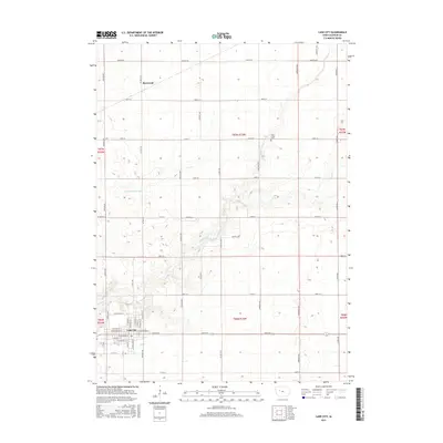
2015 Map of Lake City
USGS Topo · Published 2015About this map
Lake City anchor the southern portion of this Iowa landscape, where a dense grid of streets including W Franklin St, E Main St, and W Washington St centers the local community. To the north, the small settlement of Sherwood sits along the intersection of Co Hwy N41 and 300th St, surrounded by an extensive agricultural grid defined by section lines and drainage infrastructure. The serpentine course of Lake Creek and its tributary Lake Cr wind through the township, providing a natural contrast to the engineered precision of Drainage Ditch 198 and Drainage Ditch 10. This 2015 data illustrates the enduring rural layout of Calhoun County, including the location of the Lake Creek Cem east of Marshall Ave, which serves as a vital point of reference for local family history and genealogical research in the region.
Find a feature on this map
53 named features on this map. Tap any name to fly to it.
Don’t see what you’re looking for? This feature index may not catch every label — zoom into the map to look around manually.
Map Details
Editions of this 2015 Lake City Map
This is the sole edition of this map. No revisions or reprints were ever made.
Other maps of this area

1954 · Fort Dodge
USGS Topo · 1:250,000

1957 · Fort Dodge
USGS Topo · 1:250,000

1958 · Fort Dodge
USGS Topo · 1:250,000

1980 · Lytton
USGS Topo · 1:24,000

1980 · Rockwell City
USGS Topo · 1:24,000

1980 · Carroll NE
USGS Topo · 1:24,000

1980 · Yetter
USGS Topo · 1:24,000

1980 · Wightman
USGS Topo · 1:24,000
1980 · Lanesboro
USGS Topo · 1:24,000
1980 · Richard
USGS Topo · 1:24,000