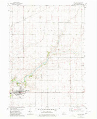
1980 Map of Lake City
USGS Topo · Published 1980About this map
Lake City serves as the primary hub of this west-central Iowa landscape, appearing here in a period of established agricultural and civic maturity. The town's grid is well-defined, featuring local institutions such as Lincoln Sch, the High Sch, and Goms Mem Park near the southern edge. The Illinois Central Gulf railroad cuts a diagonal path across the northern townships, connecting the small settlement of Sherwood to the regional rail network. The terrain is characterized by the winding course of Lake Creek, which snakes through the center of the map, and a systematic grid of drainage ditches that support the surrounding farmland. Outside the main town, the Lake Creek Cem and a local Country Club provide glimpses into the community's social and historical geography, while a rural Landing Strip and Radio Tower reflect the mid-century infrastructure of Calhoun County.
Find a feature on this map
19 named features on this map. Tap any name to fly to it.
Don’t see what you’re looking for? This feature index may not catch every label — zoom into the map to look around manually.
Map Details
Editions of this 1980 Lake City Map
This is the sole edition of this map. No revisions or reprints were ever made.
Other maps of this area

1954 · Fort Dodge
USGS Topo · 1:250,000

1957 · Fort Dodge
USGS Topo · 1:250,000

1958 · Fort Dodge
USGS Topo · 1:250,000

1980 · Lytton
USGS Topo · 1:24,000

1980 · Rockwell City
USGS Topo · 1:24,000

1980 · Carroll NE
USGS Topo · 1:24,000

1980 · Yetter
USGS Topo · 1:24,000

1980 · Wightman
USGS Topo · 1:24,000
1980 · Lanesboro
USGS Topo · 1:24,000
1980 · Richard
USGS Topo · 1:24,000