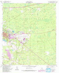
1962 Map of Lake City East
USGS Topo · Published 1993About this map
Lake City and the neighboring community of Watertown sit at a vital intersection of industry and nature in the early 1960s. The landscape transitions from the urbanized core and the Lake City Municipal Airport into the dense woodlands of the Osceola National Forest to the north and east. This era shows a community expanding along transit corridors like the Georgia Southern and Florida Railroad, while maintaining its rural character through numerous small settlements like Wilburn and Newco. Local life is anchored by institutions such as Eastside Sch and Lake City Jr College. Significant historical markers include the Truvine Cem and Price Creek Cem, alongside several country churches like Bethlehem Ch and Victory Tabernacle. The topography is defined by the swampy headwaters of Falling Creek and Price Creek, illustrating the drainage patterns of this North Florida region.
Find a feature on this map
37 named features on this map. Tap any name to fly to it.
Don’t see what you’re looking for? This feature index may not catch every label — zoom into the map to look around manually.
Map Details
Editions of this 1962 Lake City East Map
3 editions found
Other maps of this area

1954 · Valdosta
USGS Topo · 1:250,000

1958 · Valdosta
USGS Topo · 1:250,000

1959 · Valdosta
USGS Topo · 1:250,000

1961 · Deep Creek
USGS Topo · 1:24,000

1961 · White Springs East
USGS Topo · 1:24,000

1962 · Lake City East
USGS Topo · 1:24,000

1963 · Olustee
USGS Topo · 1:24,000

1963 · Ellisville
USGS Topo · 1:24,000

1963 · Columbia
USGS Topo · 1:24,000

1963 · Lake City West
USGS Topo · 1:24,000