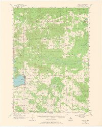
1956 Map of Lake City
USGS Topo · Published 1968About this map
The county seat of Lake City dominates the shoreline of Lake Missaukee, serving as a central hub for Missaukee County's late-1950s logging and agricultural landscape. A single branch of the Pennsylvania railroad reaches the lake's eastern edge, providing a vital link for the region's timber and farm products. The surrounding terrain is heavily defined by the Houghton Lake State Forest, where extensive wetlands like Thornton Swamp and Scafuse Marsh break up the wooded highlands.
Find a feature on this map
58 named features on this map. Tap any name to fly to it.
Don’t see what you’re looking for? This feature index may not catch every label — zoom into the map to look around manually.
Map Details
Editions of this 1956 Lake City Map
3 editions found
Other maps of this area

1949 · Fletcher
USGS Topo · 1:62,500

1950 · Fletcher
USGS Topo · 1:24,000

1954 · Traverse City
USGS Topo · 1:250,000

1956 · Kalkaska
USGS Topo · 1:62,500

1956 · Fife Lake
USGS Topo · 1:62,500

1956 · Houghton Lake
USGS Topo · 1:62,500

1956 · Cadillac North
USGS Topo · 1:62,500

1956 · Lake City
USGS Topo · 1:62,500

1957 · Harrison
USGS Topo · 1:62,500

1957 · Cadillac South
USGS Topo · 1:62,500