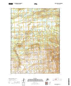
2019 Map of Lake Clark A-6 SE
USGS Topo · Published 2019About this map
Lake Clark National Preserve dominates this wild landscape, where the Chulitna River meanders across a vast expanse of wetlands and small glacial ponds. The terrain shifts from the low-lying river valley in the north to the rising elevation of Hoknede Mtn in the southeast, providing a clear picture of the transition between water-saturated plains and higher rocky peaks. This remote portion of the Lake and Peninsula Borough is defined by its natural drainage patterns, with smaller water bodies like Rock Cr feeding into the larger river system. The lack of roads or established settlements emphasizes the wilderness character of the region as it existed in the early 21st century, making it an essential reference for understanding the unmodified topography of the Lake Clark National Preserve before any future environmental shifts.
Find a feature on this map
8 named features on this map. Tap any name to fly to it.
Don’t see what you’re looking for? This feature index may not catch every label — zoom into the map to look around manually.
Map Details
Editions of this 2019 Lake Clark A-6 SE Map
This is the sole edition of this map. No revisions or reprints were ever made.
Other maps of this area

1946 · Lake Clark
USGS Topo · 1:250,000

1951 · Lake Clark
USGS Topo · 1:250,000

1952 · Iliamna
USGS Topo · 1:250,000

1954 · Lake Clark A-6
USGS Topo · 1:63,360

1954 · Lake Clark A-5
USGS Topo · 1:63,360

1954 · Iliamna D-5
USGS Topo · 1:63,360
1954 · Iliamna D-6
USGS Topo · 1:63,360

1957 · Iliamna
USGS Topo · 1:250,000

1958 · Lake Clark
USGS Topo · 1:250,000
2018 · Iliamna D-5 NW
USGS Topo · 1:25,000