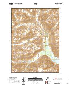
2018 Map of Lake Clark B-1 NE
USGS Topo · Published 2018About this map
Lake Clark National Park encompasses this high-altitude landscape of the Kenai Peninsula, where the steep terrain of the Aleutian Range dictates the flow of the local water systems. The Lake Fork Crescent River serves as the primary drainage through the central and eastern portions of the sheet, winding its way toward the southeast. This 2018 survey illustrates a transition from high mountain slopes into the marshy, braided wetlands that feed into Crescent Lake. The map captures a wilderness area defined by its hydrology and natural boundaries, showing the complex network of unnamed peaks and ridges that surround these vital Alaskan waterways.
Find a feature on this map
11 named features on this map. Tap any name to fly to it.
Don’t see what you’re looking for? This feature index may not catch every label — zoom into the map to look around manually.
Map Details
Editions of this 2018 Lake Clark B-1 NE Map
This is the sole edition of this map. No revisions or reprints were ever made.
Other maps of this area

1944 · Kenai
USGS Topo · 1:250,000

1946 · Lake Clark
USGS Topo · 1:250,000

1950 · Kenai
USGS Topo · 1:250,000

1951 · Lake Clark
USGS Topo · 1:250,000

1958 · Lake Clark B-1
USGS Topo · 1:63,360

1958 · Kenai B-8
USGS Topo · 1:63,360

1958 · Kenai C-8
USGS Topo · 1:63,360
1958 · Lake Clark C-1
USGS Topo · 1:63,360

1958 · Lake Clark
USGS Topo · 1:250,000

1958 · Kenai
USGS Topo · 1:250,000