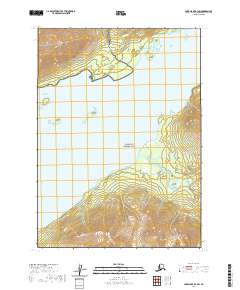
2020 Map of Lake Clark B-3 SW
USGS Topo · Published 2020About this map
Lake Clark National Park and the Lake Clark National Preserve converge here, centered on the massive glacial waters of Lake Clark. The terrain is defined by the sharp transition from the lake's surface to the high elevations of the Chigmit Mountains, anchored by Copper Mtn in the southeast. Significant drainage patterns are established by Currant Creek and Portage Cr, which feed into the lake from the surrounding heights. This survey illustrates the protected status of the Lake and Peninsula Borough's wilderness, where natural boundaries and township lines like t3n r28w and t2n r27w delineate vast tracts of federally managed land. The map provides a clear look at the hydrologic network that sustains this subarctic ecosystem, highlighting the scale of the watershed before it reaches the Cook Inlet drainage.
Find a feature on this map
10 named features on this map. Tap any name to fly to it.
Don’t see what you’re looking for? This feature index may not catch every label — zoom into the map to look around manually.
Map Details
Editions of this 2020 Lake Clark B-3 SW Map
This is the sole edition of this map. No revisions or reprints were ever made.
Other maps of this area

1946 · Lake Clark
USGS Topo · 1:250,000

1951 · Lake Clark
USGS Topo · 1:250,000

1954 · Lake Clark A-3
USGS Topo · 1:63,360

1954 · Lake Clark B-3
USGS Topo · 1:63,360

1954 · Lake Clark A-4
USGS Topo · 1:63,360

1954 · Lake Clark B-4
USGS Topo · 1:63,360

1958 · Lake Clark
USGS Topo · 1:250,000
2018 · Lake Clark B-3 NE
USGS Topo · 1:25,000
2018 · Lake Clark B-3 SE
USGS Topo · 1:25,000
2018 · Lake Clark B-4 NE
USGS Topo · 1:25,000