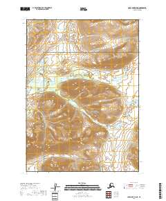
2018 Map of Lake Clark B-5 NE
USGS Topo · Published 2018About this map
The Koksetna River meanders through the heart of this landscape, carving a low-lying drainage basin through the central portion of the Lake Clark National Preserve. The topography reveals a dramatic elevation gain toward the north and south, where the terrain rises sharply from the river valley into several high peaks. This 2018 survey captures the region's wilderness character, where the intricate network of wetlands and small ponds surrounding the river indicates a complex hydrological system. The vast majority of the land is protected within the preserve, ensuring that the natural watershed of the river remains largely undisturbed by modern development.
Find a feature on this map
8 named features on this map. Tap any name to fly to it.
Don’t see what you’re looking for? This feature index may not catch every label — zoom into the map to look around manually.
Map Details
Editions of this 2018 Lake Clark B-5 NE Map
This is the sole edition of this map. No revisions or reprints were ever made.
Other maps of this area

1946 · Lake Clark
USGS Topo · 1:250,000

1951 · Lake Clark
USGS Topo · 1:250,000

1954 · Lake Clark C-4
USGS Topo · 1:63,360

1954 · Lake Clark B-5
USGS Topo · 1:63,360

1954 · Lake Clark C-5
USGS Topo · 1:63,360

1954 · Lake Clark B-4
USGS Topo · 1:63,360

1958 · Lake Clark
USGS Topo · 1:250,000
2018 · Lake Clark C-4 SW
USGS Topo · 1:25,000
2018 · Lake Clark B-5 NW
USGS Topo · 1:25,000
2018 · Lake Clark B-4 NW
USGS Topo · 1:25,000