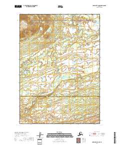
2018 Map of Lake Clark D-4 NW
USGS Topo · Published 2018About this map
Lake Clark National Preserve dominates this wild landscape, where the Telaquana River meanders across the northeastern corner of the map. This 2018 survey documents a region characterized by its lack of infrastructure, defined instead by intricate drainage patterns and vast wetland systems. The boundary between the Bethel Census Area and the Lake and Peninsula Borough bisects the southern half of the map, marking a transition between administrative zones in this remote wilderness. The topography reveals significant elevation changes in the northwest, transitioning from higher ridges down into the saturated river basins that define the local hydrology.
Find a feature on this map
9 named features on this map. Tap any name to fly to it.
Don’t see what you’re looking for? This feature index may not catch every label — zoom into the map to look around manually.
Map Details
Editions of this 2018 Lake Clark D-4 NW Map
This is the sole edition of this map. No revisions or reprints were ever made.
Other maps of this area

1946 · Lake Clark
USGS Topo · 1:250,000

1951 · Lake Clark
USGS Topo · 1:250,000

1951 · Lime Hills
USGS Topo · 1:250,000

1954 · Lime Hills A-5
USGS Topo · 1:63,360

1954 · Lime Hills A-4
USGS Topo · 1:63,360

1954 · Lake Clark D-5
USGS Topo · 1:63,360

1954 · Lake Clark D-4
USGS Topo · 1:63,360

1958 · Lake Clark
USGS Topo · 1:250,000

1958 · Lime Hills
USGS Topo · 1:250,000
2018 · Lake Clark D-4 SE
USGS Topo · 1:25,000