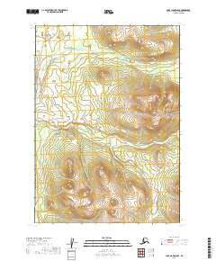
2019 Map of Lake Clark D-8 SE
USGS Topo · Published 2019About this map
The S Fork Hoholitna River meanders across the northern portion of this Alaskan wilderness within the Lake and Peninsula Borough. As documented by this 2019 survey, the landscape is defined by its topographic complexity rather than human infrastructure or settlement. The winding watercourse of the S Fork Hoholitna River represents the primary geographic feature of the terrain, set against the backdrop of the Public Land Survey System grids for townships T8N and T9N. The lack of named roads, schools, or villages emphasizes the remote character of this region of southwestern Alaska, where the hydrology and elevation contours remain the most significant markers for navigation or research.
Find a feature on this map
5 named features on this map. Tap any name to fly to it.
Don’t see what you’re looking for? This feature index may not catch every label — zoom into the map to look around manually.
Map Details
Editions of this 2019 Lake Clark D-8 SE Map
This is the sole edition of this map. No revisions or reprints were ever made.
Other maps of this area

1946 · Lake Clark
USGS Topo · 1:250,000

1951 · Lake Clark
USGS Topo · 1:250,000

1954 · Lake Clark C-7
USGS Topo · 1:63,360

1954 · Lake Clark C-8
USGS Topo · 1:63,360

1954 · Lake Clark D-8
USGS Topo · 1:63,360

1954 · Lake Clark D-7
USGS Topo · 1:63,360

1958 · Lake Clark
USGS Topo · 1:250,000
2019 · Lake Clark C-8 NW
USGS Topo · 1:25,000
2019 · Lake Clark D-7 SW
USGS Topo · 1:25,000
2019 · Lake Clark D-7 NW
USGS Topo · 1:25,000