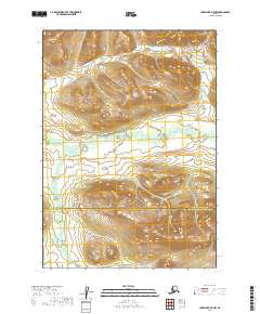
2019 Map of Lake Clark D-7 NW
USGS Topo · Published 2019About this map
The Hoholitna River meanders across the central basin of this Alaskan interior landscape, carving a low-lying valley between high ridges. Flowing eastward, the river is the primary drainage for the surrounding terrain, supplemented by the smaller Gnat Creek which enters from the south. The topographic contours reveal a landscape dominated by massive, unnamed mountain masses rising sharply from the riverbanks, reaching elevations that suggest a formidable subarctic wilderness. A significant administrative transition occurs here, marked by the boundary between the Bethel Census Area and the Lake and Peninsula Borough. This boundary bisects the quadrangle, reflecting the division between the central Kuskokwim region and the peninsula to the south. The absence of roads, trails, or structures underscores the isolation of this river valley, where the primary features are the natural waterways and the geometric precision of the Public Land Survey System lines.
Find a feature on this map
9 named features on this map. Tap any name to fly to it.
Don’t see what you’re looking for? This feature index may not catch every label — zoom into the map to look around manually.
Map Details
Editions of this 2019 Lake Clark D-7 NW Map
This is the sole edition of this map. No revisions or reprints were ever made.
Other maps of this area

1946 · Lake Clark
USGS Topo · 1:250,000

1951 · Lake Clark
USGS Topo · 1:250,000

1951 · Lime Hills
USGS Topo · 1:250,000

1954 · Lime Hills A-8
USGS Topo · 1:63,360

1954 · Lake Clark D-8
USGS Topo · 1:63,360

1954 · Lake Clark D-7
USGS Topo · 1:63,360

1954 · Lime Hills A-7
USGS Topo · 1:63,360

1958 · Lake Clark
USGS Topo · 1:250,000

1958 · Lime Hills
USGS Topo · 1:250,000
2019 · Lake Clark D-7 NE
USGS Topo · 1:25,000