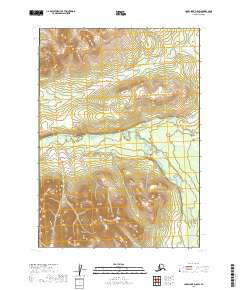
2019 Map of Lake Clark D-8 SW
USGS Topo · Published 2019About this map
The South Fork Hoholitna River carves through the center of this terrain, following a low-lying valley that separates the northern and southern uplands. In this portion of the Lake and Peninsula Borough, the river acts as the primary topographical focal point, with its course labeled alternatively as the S Fork Hoholitna River as it moves through the eastern sections. The lack of established roads or structures emphasizes the isolation of this interior Alaska wilderness, where the land is defined by elevations reaching over 2,000 feet and the intricate drainage patterns of the river valley. The map is primarily oriented around the public land survey system divisions of t9n r38w, t9n r37w, t8n r38w, and t8n r37w, providing a detailed grid for a landscape without permanent settlements.
Find a feature on this map
7 named features on this map. Tap any name to fly to it.
Don’t see what you’re looking for? This feature index may not catch every label — zoom into the map to look around manually.
Map Details
Editions of this 2019 Lake Clark D-8 SW Map
This is the sole edition of this map. No revisions or reprints were ever made.
Other maps of this area

1946 · Lake Clark
USGS Topo · 1:250,000

1950 · Taylor Mountains
USGS Topo · 1:250,000

1951 · Lake Clark
USGS Topo · 1:250,000

1951 · Taylor Mountains
USGS Topo · 1:250,000

1954 · Lake Clark C-8
USGS Topo · 1:63,360

1954 · Lake Clark D-8
USGS Topo · 1:63,360

1954 · Taylor Mountains
USGS Topo · 1:250,000

1954 · Taylor Mountains C-1
USGS Topo · 1:63,360

1954 · Taylor Mountains D-1
USGS Topo · 1:63,360

1958 · Lake Clark
USGS Topo · 1:250,000