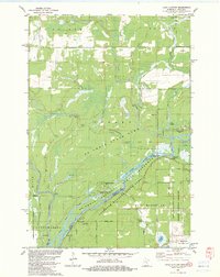
1982 Map of Lake Clayton
USGS Topo · Published 1983About this map
The St Croix River defines the borderland between Minnesota and Wisconsin in this 1980s-era topographical study, winding through a heavily protected corridor of state and national lands. The river’s importance as a thoroughfare is evident in the string of historical access points including Norway Point Landing, Nelson Landing, and Fox Landing. These landings, along with recreational sites like Norway Point Camp, mark the legacy of river-based travel and resource management in the region.
Find a feature on this map
44 named features on this map. Tap any name to fly to it.
Don’t see what you’re looking for? This feature index may not catch every label — zoom into the map to look around manually.
Map Details
Editions of this 1982 Lake Clayton Map
This is the sole edition of this map. No revisions or reprints were ever made.
Other maps of this area

1950 · Grantsburg
USGS Topo · 1:48,000

1953 · Duluth
USGS Topo · 1:250,000

1953 · Stillwater
USGS Topo · 1:250,000

1955 · Stillwater
USGS Topo · 1:250,000

1958 · Stillwater
USGS Topo · 1:250,000

1958 · Duluth
USGS Topo · 1:250,000

1961 · Sandstone
USGS Topo · 1:62,500

1961 · Pine City
USGS Topo · 1:62,500

1962 · Cloverdale
USGS Topo · 1:62,500

1962 · Grantsburg
USGS Topo · 1:62,500