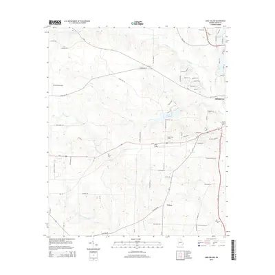
2014 Map of Lake Collins
USGS Topo · Published 2014About this map
Muckalee Cr and its tributaries define the rolling landscape west of Americus in this early 21st-century documentation of Sumter County. The map details a transition from the urban edge of the county seat to a rural interior punctuated by small settlements and family-named infrastructure. McMath Millpond and Parkers Mill Cr suggest a legacy of water-powered industry, while localized aviation is represented by Peterson Field Airport and Lowell Field Airport. Genealogists may find particular value in the locations of Antioch Cem near the creek and Benevolence Cem in the southeastern quadrant. The settlement patterns of New Point and Thalean appear alongside a network of established country roads, including Youngs Mill Rd and Tallent Store Rd, which connect the outlying farms to the residential developments around Lake Collins and Statham Lake.
Find a feature on this map
76 named features on this map. Tap any name to fly to it.
Don’t see what you’re looking for? This feature index may not catch every label — zoom into the map to look around manually.
Map Details
Editions of this 2014 Lake Collins Map
This is the sole edition of this map. No revisions or reprints were ever made.
Other maps of this area

1953 · Dothan
USGS Topo · 1:250,000

1954 · Dothan
USGS Topo · 1:250,000

1955 · Dothan
USGS Topo · 1:250,000

1955 · Phenix City
USGS Topo · 1:250,000

1956 · Leslie
USGS Topo · 1:62,500

1957 · Phenix City
USGS Topo · 1:250,000

1958 · Phenix City
USGS Topo · 1:250,000

1972 · Ellaville South
USGS Topo · 1:24,000
1972 · Andersonville
USGS Topo · 1:24,000
1973 · Americus
USGS Topo · 1:24,000