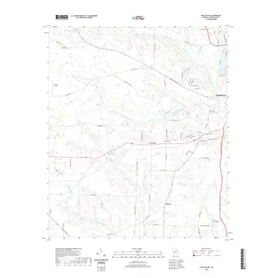
2020 Map of Lake Collins
USGS Topo · Published 2020About this map
Muckaloochee Cr and its various tributaries, including Little Muckaloochee Cr and Wolf Creek, define the drainage patterns of this Sumter County landscape west of Americus. The area is characterized by a network of rural routes such as Americus Friendship Rd and McMath Mill Rd Exd, connecting small settlements and aviation landmarks like Peterson Field and Lowell Field. This modern survey illustrates the persistent rural character of the region, where family-named roads like Buchanan Rd and Fox Stephens Rd lead to long-standing community landmarks.
Find a feature on this map
74 named features on this map. Tap any name to fly to it.
Don’t see what you’re looking for? This feature index may not catch every label — zoom into the map to look around manually.
Map Details
Editions of this 2020 Lake Collins Map
This is the sole edition of this map. No revisions or reprints were ever made.
Other maps of this area

1953 · Dothan
USGS Topo · 1:250,000

1954 · Dothan
USGS Topo · 1:250,000

1955 · Dothan
USGS Topo · 1:250,000

1955 · Phenix City
USGS Topo · 1:250,000

1956 · Leslie
USGS Topo · 1:62,500

1957 · Phenix City
USGS Topo · 1:250,000

1958 · Phenix City
USGS Topo · 1:250,000

1972 · Ellaville South
USGS Topo · 1:24,000
1972 · Andersonville
USGS Topo · 1:24,000
1973 · Americus
USGS Topo · 1:24,000