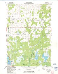
1984 Map of Lake Dexter
USGS Topo · Published 1984About this map
Cranberry Bog complexes and slow-moving watercourses define this central Wisconsin landscape at the intersection of Wood, Hansen, and Dexter townships. The map documents a unique transition in transport and land use, where an Old Railroad Grade and the Green Bay and Western Railroad Grade cut through the marshy lowlands near Dexterville. These corridors, alongside the winding paths of Hemlock Creek and Little Hemlock Creek, reflect the region's historical reliance on timber and wetland agriculture.
Find a feature on this map
31 named features on this map. Tap any name to fly to it.
Don’t see what you’re looking for? This feature index may not catch every label — zoom into the map to look around manually.
Map Details
Editions of this 1984 Lake Dexter Map
This is the sole edition of this map. No revisions or reprints were ever made.
Other maps of this area

1953 · Eau Claire
USGS Topo · 1:250,000

1954 · Marshfield
USGS Topo · 1:62,500

1955 · Green Bay
USGS Topo · 1:250,000

1956 · Milladore
USGS Topo · 1:48,000

1957 · Wisconsin Rapids
USGS Topo · 1:48,000

1957 · Pittsville
USGS Topo · 1:48,000

1958 · Eau Claire
USGS Topo · 1:250,000

1964 · Eau Claire
USGS Topo · 1:250,000

1967 · Wisconsin Rapids
USGS Topo · 1:62,500

1967 · Pittsville
USGS Topo · 1:62,500