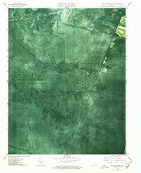
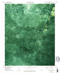
1977 Map of Lake Drummond NW
USGS Topo · Published 1978About this map
The Great Dismal Swamp National Wildlife Refuge dominates this orthophotomap, showing the dense canopy and artificial drainage networks that define this interior wilderness during the late 1970s. The landscape is characterized by an extensive system of historic canals, including the long Washington Ditch and the Jericho Ditch, which slice through the swamp in straight, geometric lines. These waterways provide a clear record of early attempts to manage and traverse the boggy terrain, intersecting at points like Five Mile Ditch and Camp Ditch.
Find a feature on this map
28 named features on this map. Tap any name to fly to it.
Don’t see what you’re looking for? This feature index may not catch every label — zoom into the map to look around manually.
Map Details
Editions of this 1977 Lake Drummond NW Map
3 editions found

Other maps of this area

1907 · Norfolk
USGS Topo · 1:125,000

1919 · Smithfield
USGS Topo · 1:62,500

1919 · Suffolk
USGS Topo · 1:62,500

1921 · Newport News
USGS Topo · 1:62,500

1940 · Lake Drummond
USGS Topo · 1:62,500

1944 · Norfolk South
USGS Topo · 1:25,000

1945 · Lake Drummond
USGS Topo · 1:62,500

1948 · Norfolk South
USGS Topo · 1:24,000

1949 · Chuckatuck
USGS Topo · 1:24,000

1952 · Bowers Hill
USGS Topo · 1:24,000