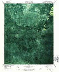
1977 Map of Lake Drummond NW
USGS Topo · Published 1987About this map
Great Dismal Swamp dominates this landscape, showing a complex network of artificial waterways that defined the region's historical drainage and industrial efforts. Based on 1973 aerial photography and 1940 planetable surveys, the orthophotomap reveals the dense forest cover and precise lines of the Washington Ditch and Western Ditch. These straight-line channels, including Williamson Ditch and Hudnell Ditch, reflect centuries of attempts to manage the water levels of this expansive wetland.
Find a feature on this map
18 named features on this map. Tap any name to fly to it.
Don’t see what you’re looking for? This feature index may not catch every label — zoom into the map to look around manually.
Map Details
Editions of this 1977 Lake Drummond NW Map
3 editions found
Other maps of this area

1907 · Norfolk
USGS Topo · 1:125,000

1919 · Smithfield
USGS Topo · 1:62,500

1919 · Suffolk
USGS Topo · 1:62,500

1921 · Newport News
USGS Topo · 1:62,500

1940 · Lake Drummond
USGS Topo · 1:62,500

1944 · Norfolk South
USGS Topo · 1:25,000

1945 · Lake Drummond
USGS Topo · 1:62,500

1948 · Norfolk South
USGS Topo · 1:24,000

1949 · Chuckatuck
USGS Topo · 1:24,000
1952 · Bowers Hill
USGS Topo · 1:24,000