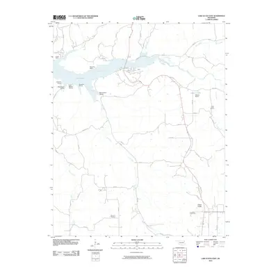
2010 Map of Lake Eucha East
USGS Topo · Published 2010About this map
Lake Eucha dominates the western landscape of this Delaware County region, where the waters of Spavinaw Creek feed into the reservoir. This 2010 topographic representation focuses on the rural eastern reaches of the lake, capturing the transition from open water to the winding creek beds that define the local drainage. The small settlement of Cloud Creek serves as a primary geographic anchor in the southeastern portion of the map, situated amidst a network of rural roads that traverse the varying elevations of the Oklahoma terrain. By this era, the landscape shows a clear pattern of dispersed rural homesteads and agricultural plots, punctuated by the natural features that have long dictated the area's development and water management.
Find a feature on this map
3 named features on this map. Tap any name to fly to it.
Don’t see what you’re looking for? This feature index may not catch every label — zoom into the map to look around manually.
Map Details
Editions of this 2010 Lake Eucha East Map
This is the sole edition of this map. No revisions or reprints were ever made.
Other maps of this area

1899 · Siloam Springs
USGS Topo · 1:125,000

1903 · Siloam Springs
USGS Topo · 1:125,000

1904 · Siloam Springs
USGS Topo · 1:125,000

1954 · Tulsa
USGS Topo · 1:250,000

1958 · Tulsa
USGS Topo · 1:250,000

1963 · Tulsa
USGS Topo · 1:250,000

1971 · Kenwood
USGS Topo · 1:24,000

1971 · Jay SE
USGS Topo · 1:24,000
1971 · Jay
USGS Topo · 1:24,000
1971 · Sycamore
USGS Topo · 1:24,000