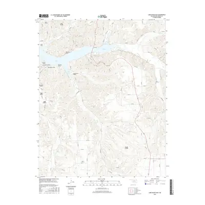
2016 Map of Lake Eucha East
USGS Topo · Published 2016About this map
Lake Eucha dominates the northern landscape of this Oklahoma territory, where the impounded waters of Spavinaw Cr and Beaty Cr fill deep inlets like Brush Creek Bay and the Dry Creek Arm. The surrounding terrain in Delaware County is defined by a dense network of hollows and bluffs, including Black Fox Bluff and Lanes Bluff, which overlook the expanding reservoir. South of the shoreline, the community of Cloud Creek serves as a local anchor amidst a grid of rural county roads. This 2016 survey documents the enduring physical landmarks of the region, from the open expanses of Elkhorn Prairie to the quiet locations of the Cloud Creek Cem and Black Fox Cem. The map provides a clear look at the modern interface between managed water resources and the established rural settlements of the Ozark foothills.
Find a feature on this map
88 named features on this map. Tap any name to fly to it.
Don’t see what you’re looking for? This feature index may not catch every label — zoom into the map to look around manually.
Map Details
Editions of this 2016 Lake Eucha East Map
This is the sole edition of this map. No revisions or reprints were ever made.
Other maps of this area

1899 · Siloam Springs
USGS Topo · 1:125,000

1903 · Siloam Springs
USGS Topo · 1:125,000

1904 · Siloam Springs
USGS Topo · 1:125,000

1954 · Tulsa
USGS Topo · 1:250,000

1958 · Tulsa
USGS Topo · 1:250,000

1963 · Tulsa
USGS Topo · 1:250,000

1971 · Kenwood
USGS Topo · 1:24,000

1971 · Jay SE
USGS Topo · 1:24,000
1971 · Jay
USGS Topo · 1:24,000
1971 · Sycamore
USGS Topo · 1:24,000