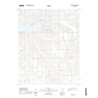
2018 Map of Lake Eucha East
USGS Topo · Published 2018About this map
Lake Eucha dominates the northern landscape of this Delaware County survey, where the dammed waters of Spavinaw Cr and Beaty Cr reach into the winding valleys of northeastern Oklahoma. The shoreline is defined by deep inlets such as Brush Creek Bay and Dry Creek Arm, overlooked by landmarks like Black Fox Bluff and Lanes Bluff. This topography forces a fragmented road network of local routes like Co RD 595 and Shore RD that navigate between the steep-sided ravines of Teesquatnee Hollow and Runaway Hollow.
Find a feature on this map
83 named features on this map. Tap any name to fly to it.
Don’t see what you’re looking for? This feature index may not catch every label — zoom into the map to look around manually.
Map Details
Editions of this 2018 Lake Eucha East Map
This is the sole edition of this map. No revisions or reprints were ever made.
Other maps of this area

1899 · Siloam Springs
USGS Topo · 1:125,000

1903 · Siloam Springs
USGS Topo · 1:125,000

1904 · Siloam Springs
USGS Topo · 1:125,000

1954 · Tulsa
USGS Topo · 1:250,000

1958 · Tulsa
USGS Topo · 1:250,000

1963 · Tulsa
USGS Topo · 1:250,000

1971 · Kenwood
USGS Topo · 1:24,000

1971 · Jay SE
USGS Topo · 1:24,000
1971 · Jay
USGS Topo · 1:24,000
1971 · Sycamore
USGS Topo · 1:24,000