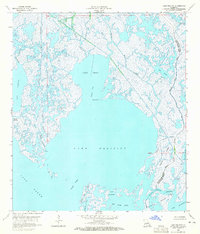
1964 Map of Lake Felicity
USGS Topo · Published 1965About this map
Bayou Jean Lacroix Oil and Gas Field dominates the northern marshlands of this mid-1960s survey, marking the intersection of natural hydrology and industrial extraction in Terrebonne Parish. The landscape is a complex maze of interconnected waterways, where Lake Chien and Lake Felicity are linked by the Grand Cut. These wide, shallow basins are surrounded by shifting landforms like Felicity Island and the Formation Islands, illustrating the fragile nature of the Louisiana gulf coast. Several Drill Holes and a Light are noted among the bayous, signaling the ongoing human presence within the tidal environment. The map details the transition from larger open waters like Lake Barre to intricate bayou systems, including Bayou Leblanc and Bayou St Jean Charles, which serve as the primary conduits through the wetlands.
Find a feature on this map
31 named features on this map. Tap any name to fly to it.
Don’t see what you’re looking for? This feature index may not catch every label — zoom into the map to look around manually.
Map Details
Editions of this 1964 Lake Felicity Map
4 editions found
Other maps of this area

1894 · Timbalier
USGS Topo · 1:62,500

1894 · Lake Felicity
USGS Topo · 1:62,500

1894 · Dulac
USGS Topo · 1:62,500

1935 · Bourbeux
USGS Topo · 1:31,680

1935 · Viguerie Canal
USGS Topo · 1:31,680

1935 · Montegut
USGS Topo · 1:31,680

1935 · Bay Courant
USGS Topo · 1:31,680

1935 · Golden Meadow
USGS Topo · 1:31,680

1935 · Pelican Pass
USGS Topo · 1:31,680

1939 · Lake Felicity
USGS Topo · 1:62,500