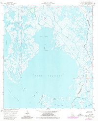
1964 Map of Lake Felicity
USGS Topo · Published 1980About this map
Lake Felicity and its surrounding marshlands dominate this coastal landscape in southern Terrebonne Parish. The map reveals a complex aquatic geography defined by the Bayou Jean Lacroix Oil and Gas Field to the north and the expansive Lake Chien which connects via the Grand Cut to larger water bodies. The small settlement of Russo sits at the edge of the wetlands, while the interior is dotted with evocatively named features like Old Lady Lake, Lake du Diable, and the Fornation Islands. Industrial activity is evident through scattered Drill Hole locations, contrasting with the natural wandering paths of Bayou Guillaume and Felicity Bayou. The transition from open water to tidal marsh is marked by numerous cuts and passes, including Deep Cut and Coupe Creuse, illustrating the fluid nature of the Louisiana shoreline before later decades of erosion.
Find a feature on this map
38 named features on this map. Tap any name to fly to it.
Don’t see what you’re looking for? This feature index may not catch every label — zoom into the map to look around manually.
Map Details
Editions of this 1964 Lake Felicity Map
4 editions found
Other maps of this area

1894 · Timbalier
USGS Topo · 1:62,500

1894 · Lake Felicity
USGS Topo · 1:62,500

1894 · Dulac
USGS Topo · 1:62,500

1935 · Bourbeux
USGS Topo · 1:31,680

1935 · Viguerie Canal
USGS Topo · 1:31,680

1935 · Montegut
USGS Topo · 1:31,680

1935 · Bay Courant
USGS Topo · 1:31,680

1935 · Golden Meadow
USGS Topo · 1:31,680

1935 · Pelican Pass
USGS Topo · 1:31,680

1939 · Lake Felicity
USGS Topo · 1:62,500