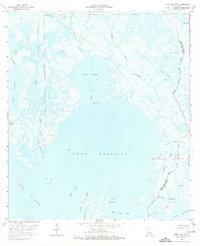
1964 Map of Lake Felicity
USGS Topo · Published 1976About this map
Bayou Jean Lacroix Oil and Gas Field anchors the northern reaches of this coastal landscape, illustrating the mid-century industrial presence amidst the tidal marshes of Terrebonne Parish. The intricate network of waterways, including St Jean Charles Bayou and Bayou Jean Lacroix, defines the transition from open water to marshland. Significant bodies of water such as Lake Felicity and Lake Chien are separated by natural landmarks like Grand Point and the Grand Cut. This 1963-64 survey detail provides a window into the labyrinthine geography of the gulf coast before decades of coastal erosion, showing specific family-named or local features like Lake Billiot, Old Lady Lake, and the small landing at Russo. The boundary between Terrebonne and Lafourche Parish follows the winding course of Bayou au Chien and Pointe au Chien.
Find a feature on this map
36 named features on this map. Tap any name to fly to it.
Don’t see what you’re looking for? This feature index may not catch every label — zoom into the map to look around manually.
Map Details
Editions of this 1964 Lake Felicity Map
4 editions found
Other maps of this area

1894 · Timbalier
USGS Topo · 1:62,500

1894 · Lake Felicity
USGS Topo · 1:62,500

1894 · Dulac
USGS Topo · 1:62,500

1935 · Bourbeux
USGS Topo · 1:31,680

1935 · Viguerie Canal
USGS Topo · 1:31,680

1935 · Montegut
USGS Topo · 1:31,680

1935 · Bay Courant
USGS Topo · 1:31,680

1935 · Golden Meadow
USGS Topo · 1:31,680

1935 · Pelican Pass
USGS Topo · 1:31,680

1939 · Lake Felicity
USGS Topo · 1:62,500