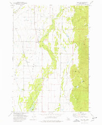
1973 Map of Lake Fork
USGS Topo · Published 1977About this map
Long Valley in central Idaho is defined here by its complex irrigation network and the transition from fertile valley floor to the foothills of Timber Ridge. The settlement of Lake Fork sits at a geographic crossroads near where the Old Union Pacific RR Grade once tracked through the valley. This 1973 survey details an economy reliant on water management, featuring the Irrigation District Canal and numerous siphons, flumes, and storage bins that support the surrounding ranchlands. The southern portion of the map is dominated by the northern reaches of Cascade Reservoir, which significantly altered the local drainage of Lake Fork and Mud Creek. Genealogists will find the Finn Cem and Spink Cem particularly noteworthy, along with the smaller community of Norwood and the landing strip that underscores the region's connectivity.
Find a feature on this map
45 named features on this map. Tap any name to fly to it.
Don’t see what you’re looking for? This feature index may not catch every label — zoom into the map to look around manually.
Map Details
Editions of this 1973 Lake Fork Map
2 editions found
Other maps of this area

1911 · Meadows
USGS Topo · 1:125,000

1954 · Gold Fork
USGS Topo · 1:62,500

1954 · Cascade
USGS Topo · 1:62,500

1955 · Baker
USGS Topo · 1:250,000

1957 · Challis
USGS Topo · 1:250,000

1959 · Baker
USGS Topo · 1:250,000

1960 · Challis
USGS Topo · 1:250,000

1963 · Challis
USGS Topo · 1:250,000
1973 · Meadows
USGS Topo · 1:24,000
1973 · No Business Mtn
USGS Topo · 1:24,000