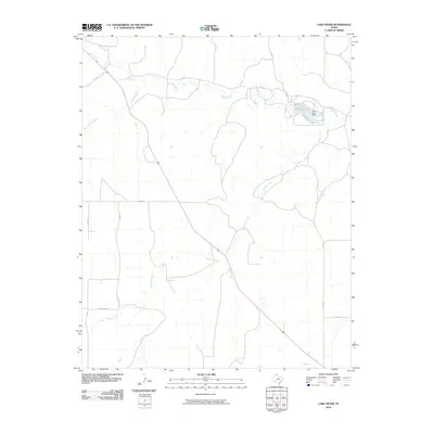
2010 Map of Lake Fryer
USGS Topo · Published 2010About this map
Lake Fryer and its associated Lake Fryer Dam serve as the primary focal point of this northern Ochiltree County landscape. The drainage system of the High Plains is clearly defined here, with Wolf Creek and its tributary South Wolf Creek cutting through the terrain. The map illustrates a rural Texas Panhandle infrastructure dominated by a grid of county roads, including Co Rd U and Co Rd W, which navigate the various creek breaks. In the southern portion of the quadrangle, the presence of Leslie Ranch Rd and Northup Creek highlights the ranching heritage of the area. This 2010 survey provides a precise view of the water management and transportation networks in a part of Texas where the topography is shaped by these seasonal and perennial waterways.
Find a feature on this map
14 named features on this map. Tap any name to fly to it.
Don’t see what you’re looking for? This feature index may not catch every label — zoom into the map to look around manually.
Map Details
Editions of this 2010 Lake Fryer Map
This is the sole edition of this map. No revisions or reprints were ever made.
Other maps of this area

1954 · Perryton
USGS Topo · 1:250,000

1958 · Perryton
USGS Topo · 1:250,000

1972 · Booker SE
USGS Topo · 1:24,000

1973 · Booker SW
USGS Topo · 1:24,000

1973 · Sourdough Creek NE
USGS Topo · 1:24,000

1973 · Pickett Ranch Creek
USGS Topo · 1:24,000

1973 · Perryton SE
USGS Topo · 1:24,000

1973 · Lake Fryer
USGS Topo · 1:24,000
1973 · Barton Creek
USGS Topo · 1:24,000
1973 · Lake Fryer NE
USGS Topo · 1:24,000