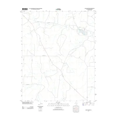
2012 Map of Lake Fryer
USGS Topo · Published 2012About this map
Lake Fryer serves as a focal point in this section of Ochiltree County, where the High Plains are dissected by a network of drainage systems. The landscape is defined by the winding course of Wolf Cr and its tributary, S Wolf Cr, which cut through the terrain north of the lake. To the south, the watershed transitions toward Northup Cr, illustrating the subtle topographic shifts characteristic of the Texas Panhandle. Transportation across this rural expanse is anchored by a grid of county roads and larger thoroughfares like Ranch Road 759. The inclusion of Leslie Ranch Rd and Wolf Creek Rd highlights the long-standing ranching heritage of the region, providing researchers with a look at land use and access patterns in the early 21st century.
Find a feature on this map
14 named features on this map. Tap any name to fly to it.
Don’t see what you’re looking for? This feature index may not catch every label — zoom into the map to look around manually.
Map Details
Editions of this 2012 Lake Fryer Map
This is the sole edition of this map. No revisions or reprints were ever made.
Other maps of this area

1954 · Perryton
USGS Topo · 1:250,000

1958 · Perryton
USGS Topo · 1:250,000

1972 · Booker SE
USGS Topo · 1:24,000

1973 · Booker SW
USGS Topo · 1:24,000

1973 · Sourdough Creek NE
USGS Topo · 1:24,000

1973 · Pickett Ranch Creek
USGS Topo · 1:24,000

1973 · Perryton SE
USGS Topo · 1:24,000

1973 · Lake Fryer
USGS Topo · 1:24,000
1973 · Barton Creek
USGS Topo · 1:24,000
1973 · Lake Fryer NE
USGS Topo · 1:24,000