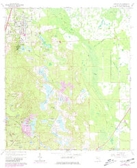
1966 Map of Lake Helen
USGS Topo · Published 1981About this map
Lake Helen serves as the focal point of this inland Volusia County landscape, surrounded by an intricate network of freshwater bodies and wetlands. In the mid-1960s, the spiritualist community of Cassadaga and the emerging suburban footprint of Deltona to the southwest represent distinct phases of Florida's residential development. The terrain is defined by its water, from the clustered Three Island Lakes and Waterman Lakes to the expansive Marsh Swamp that dominates the eastern portion of the quadrangle. Transportation patterns are visible through the grid of Lake Helen, including Pennsylvania Ave and Main St, while the remnants of earlier infrastructure are preserved in the form of an Old RR Grade and Old Railroad Grade cutting through the hammocks and pine flatwoods. This survey captures a moment before the massive central Florida growth of the late 20th century, documenting the early expansion of the Deltona Country Club and the rural isolation of landmarks like Alberts Crossing.
Find a feature on this map
74 named features on this map. Tap any name to fly to it.
Don’t see what you’re looking for? This feature index may not catch every label — zoom into the map to look around manually.
Map Details
Editions of this 1966 Lake Helen Map
4 editions found
Other maps of this area

1949 · Osceola
USGS Topo · 1:24,000

1952 · Samsula
USGS Topo · 1:24,000

1954 · Daytona Beach
USGS Topo · 1:250,000

1955 · Orlando
USGS Topo · 1:250,000

1957 · Orlando
USGS Topo · 1:250,000

1958 · Orlando
USGS Topo · 1:250,000

1958 · Daytona Beach
USGS Topo · 1:250,000

1962 · Orlando
USGS Topo · 1:250,000

1962 · Daytona Beach SW
USGS Topo · 1:24,000

1964 · Daytona Beach
USGS Topo · 1:250,000