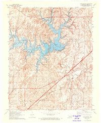
1971 Map of Lake Heyburn
USGS Topo · Published 1973About this map
Lake Heyburn and its sprawling reservoir waters dominate this early 1970s landscape in Creek County, reflecting the mid-century transformation of the Oklahoma terrain for flood control and recreation. The Lake Heyburn State Park surrounds the central water body, where various Recreation Areas, a Gaging Station, and Waterworks indicate a managed aquatic environment. The map captures the meeting of traditional land uses and modern infrastructure, shown by the intersection of the St Louis San Francisco railroad and the Turner Toll Road cutting across the southern half of the quadrangle.
Find a feature on this map
26 named features on this map. Tap any name to fly to it.
Don’t see what you’re looking for? This feature index may not catch every label — zoom into the map to look around manually.
Map Details
Editions of this 1971 Lake Heyburn Map
This is the sole edition of this map. No revisions or reprints were ever made.
Other maps of this area

1901 · Nuyaka
USGS Topo · 1:125,000

1912 · Hominy
USGS Topo · 1:125,000

1914 · Kiefer
USGS Topo · 1:62,500

1915 · Hominy
USGS Topo · 1:125,000

1916 · Kiefer
USGS Topo · 1:62,500

1916 · Bristow
USGS Topo · 1:62,500

1954 · Oklahoma City
USGS Topo · 1:250,000

1955 · Enid
USGS Topo · 1:250,000

1957 · Oklahoma City
USGS Topo · 1:250,000

1958 · Enid
USGS Topo · 1:250,000