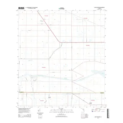
2015 Map of Lake Hicpochee
USGS Topo · Published 2015About this map
Lake Hicpochee and the managed water systems of south Florida define this landscape at the intersection of Glades and Hendry counties. The Caloosahatchee Canal and the Okeechobee Waterway cut through the terrain, illustrating the region's complex engineering and drainage history. Local family names and agricultural legacies are evident through features like Donald Peeples Pond, Peeples road, and Graham Dairy Rd, while the location of Storey reflects the small, often roadside-centered community nodes found in this part of the state. The presence of Beautiful Hammock and Woodyard Hammock highlights traditional Florida landscape features—elevated stands of hardwoods—standing in contrast to the surrounding water-managed plains. Infrastructure for local transit and cross-state movement is anchored by SR-80 and SR-78, with the Negro Jim Hammock Bridge serving as a specific landmark in the southern portion of the quadrangle.
Find a feature on this map
36 named features on this map. Tap any name to fly to it.
Don’t see what you’re looking for? This feature index may not catch every label — zoom into the map to look around manually.
Map Details
Editions of this 2015 Lake Hicpochee Map
This is the sole edition of this map. No revisions or reprints were ever made.
Other maps of this area

1956 · West Palm Beach
USGS Topo · 1:250,000

1957 · West Palm Beach
USGS Topo · 1:250,000

1958 · West Palm Beach
USGS Topo · 1:250,000

1958 · Goodno
USGS Topo · 1:24,000

1958 · Felda NE
USGS Topo · 1:24,000
1958 · Palmdale
USGS Topo · 1:24,000

1970 · Moore Haven
USGS Topo · 1:24,000
1970 · Lakeport
USGS Topo · 1:24,000

1970 · La Belle 4 NW
USGS Topo · 1:24,000

1970 · La Belle 4 NE
USGS Topo · 1:24,000