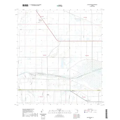
2021 Map of Lake Hicpochee
USGS Topo · Published 2021About this map
Lake Hicpochee and its surrounding wetlands dominate this landscape at the intersection of the Caloosahatchee Canal and the Okeechobee Waterway. The terrain is defined by low-lying marshlands interspersed with hammocks—dense stands of hardwood trees on slightly elevated ground—including the distinctly named Beautiful Hammock and Woodyard Hammock. This area represents a critical hydraulic link in South Florida's water management system, where the waterway serves both as a commercial artery and a recreational path for travelers on the Okeechobee Waterway Canoe Trail.
Find a feature on this map
36 named features on this map. Tap any name to fly to it.
Don’t see what you’re looking for? This feature index may not catch every label — zoom into the map to look around manually.
Map Details
Editions of this 2021 Lake Hicpochee Map
This is the sole edition of this map. No revisions or reprints were ever made.
Other maps of this area

1956 · West Palm Beach
USGS Topo · 1:250,000

1957 · West Palm Beach
USGS Topo · 1:250,000

1958 · West Palm Beach
USGS Topo · 1:250,000

1958 · Goodno
USGS Topo · 1:24,000

1958 · Felda NE
USGS Topo · 1:24,000
1958 · Palmdale
USGS Topo · 1:24,000

1970 · Moore Haven
USGS Topo · 1:24,000
1970 · Lakeport
USGS Topo · 1:24,000

1970 · La Belle 4 NW
USGS Topo · 1:24,000

1970 · La Belle 4 NE
USGS Topo · 1:24,000