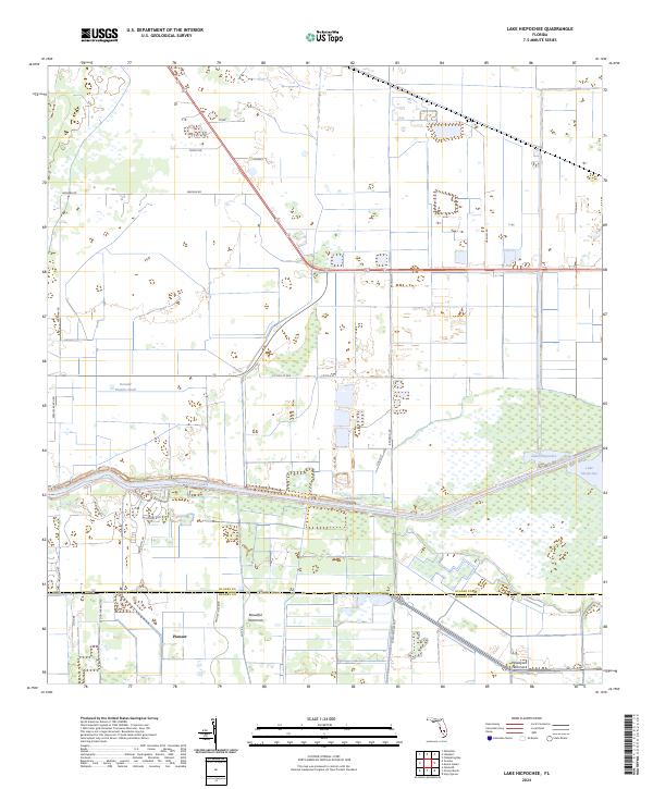
2024 Map of Lake Hicpochee
USGS Topo · Published 2024About this map
The Caloosahatchee Canal and Okeechobee Waterway dominate this Florida interior landscape, cutting through the marshy terrain that characterizes the area surrounding Lake Hicpochee. The map illustrates a region defined by agricultural development and water management, with extensive grid-patterned irrigation and drainage infrastructure supporting local farms. The boundary between Glades and Hendry counties bisects the southern half of the quadrangle, where the settlement of Pioneer sits near Hendry Isles Blvd. Significant indigenous and natural history is noted through the presence of the Seminole Indian Mound and named woodland stands like Beautiful Hammock and Woodyard Hammock. These features, along with localized landmarks like Donald Peeples Pond and Storey, provide a detailed record of land ownership and traditional use in the Florida Glades.
Find a feature on this map
35 named features on this map. Tap any name to fly to it.
Don’t see what you’re looking for? This feature index may not catch every label — zoom into the map to look around manually.
Map Details
Editions of this 2024 Lake Hicpochee Map
This is the sole edition of this map. No revisions or reprints were ever made.
Other maps of this area

1956 · West Palm Beach
USGS Topo · 1:250,000

1957 · West Palm Beach
USGS Topo · 1:250,000

1958 · West Palm Beach
USGS Topo · 1:250,000

1958 · Goodno
USGS Topo · 1:24,000

1958 · Felda NE
USGS Topo · 1:24,000
1958 · Palmdale
USGS Topo · 1:24,000

1970 · Moore Haven
USGS Topo · 1:24,000
1970 · Lakeport
USGS Topo · 1:24,000

1970 · La Belle 4 NW
USGS Topo · 1:24,000

1970 · La Belle 4 NE
USGS Topo · 1:24,000