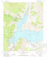
1972 Map of Lake Isabella North
USGS Topo · Published 1986About this map
Wofford Heights and the surrounding shores of Isabella Lake reflect a landscape shaped by mid-century water management and recreation within the Sequoia National Forest. The map documents the critical infrastructure of the Isabella Main Dam and Isabella Auxiliary Dam, which control the Kern River and its South Fork. Settlement patterns are concentrated in planned communities like Mountain Mesa and Squirrel Mountain Valley, while the surrounding terrain remains dotted with remnants of the area's extraction history.
Find a feature on this map
61 named features on this map. Tap any name to fly to it.
Don’t see what you’re looking for? This feature index may not catch every label — zoom into the map to look around manually.
Map Details
Editions of this 1972 Lake Isabella North Map
3 editions found
Other maps of this area

1906 · Kernville
USGS Topo · 1:125,000

1908 · Kernville
USGS Topo · 1:125,000

1920 · Delonagha
USGS Topo · 1:62,500

1926 · Glennville
USGS Topo · 1:62,500

1936 · Tobias Peak
USGS Topo · 1:125,000

1943 · Tobias Peak
USGS Topo · 1:125,000

1943 · Isabella
USGS Topo · 1:62,500

1945 · Tobias Peak
USGS Topo · 1:62,500

1948 · Bakersfield
USGS Topo · 1:250,000

1955 · Bakersfield
USGS Topo · 1:250,000