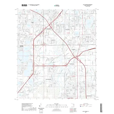
2021 Map of Lake Jessamine
USGS Topo · Published 2021About this map
Orlando and its southern suburbs are defined by an intricate network of freshwater lakes and modern infrastructure in this 2021 survey. The landscape is characterized by established residential communities like Oak Ridge, Sky Lake, and Tangelo Park, interspersed with large water bodies such as Lake Jessamine and Big Sand Lake. The presence of the Florida College of Integrative Medicine and the large Universal Technical Institute campus highlights the area's role as an educational and commercial hub. The drainage of Shingle Cr winds through the center of the sheet, providing a natural contrast to the dense grid of major thoroughfares like W Sand Lake Rd and Central Florida Pkwy. Local history is anchored by several burial grounds, including Oak Ridge Cem and Taft Cem, which sit among the evolving residential developments of Williamsburg and Southchase.
Find a feature on this map
54 named features on this map. Tap any name to fly to it.
Don’t see what you’re looking for? This feature index may not catch every label — zoom into the map to look around manually.
Map Details
Editions of this 2021 Lake Jessamine Map
This is the sole edition of this map. No revisions or reprints were ever made.
Other maps of this area

1953 · Lake Jessamine
USGS Topo · 1:24,000

1953 · St Cloud North
USGS Topo · 1:24,000

1953 · Pine Castle
USGS Topo · 1:24,000

1953 · Kissimmee
USGS Topo · 1:24,000

1953 · Windermere
USGS Topo · 1:24,000

1953 · Intercession City
USGS Topo · 1:24,000

1955 · Orlando
USGS Topo · 1:250,000

1956 · Winter Garden
USGS Topo · 1:24,000

1956 · Orlando West
USGS Topo · 1:24,000

1956 · Orlando East
USGS Topo · 1:24,000