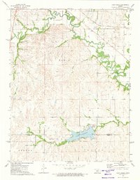
1972 Map of Lake Kahola
USGS Topo · Published 1974About this map
Lake Kahola and its surrounding drainage basin define this Kansas landscape on the border of Morris and Chase counties. The reservoir, complete with its Picnic Area and spillway, serves as a focal point for the region just north of the Old Indian Treaty Boundary. The terrain is deeply dissected by a network of waterways, including Wolf Creek, Fourmile Creek, and Walker Branch, which flow toward the meandering Neosho River in the northeast. Industrial activity in the early 1970s is evidenced by a Gravel Pit and several Quarry sites located near the Missouri Pacific railroad line. The map captures a transition from the structured township boundaries of TWP 1, Strong, and Toledo to the winding, natural paths of Kahola Creek and Indian Cr.
Find a feature on this map
19 named features on this map. Tap any name to fly to it.
Don’t see what you’re looking for? This feature index may not catch every label — zoom into the map to look around manually.
Map Details
Editions of this 1972 Lake Kahola Map
This is the sole edition of this map. No revisions or reprints were ever made.
Other maps of this area

1885 · Eskridge
USGS Topo · 1:125,000

1888 · Emporia
USGS Topo · 1:125,000

1889 · Parkerville
USGS Topo · 1:125,000

1889 · Eskridge
USGS Topo · 1:125,000

1894 · Emporia
USGS Topo · 1:125,000

1894 · Eskridge
USGS Topo · 1:125,000

1894 · Parkerville
USGS Topo · 1:125,000

1898 · Cottonwood Falls
USGS Topo · 1:125,000

1955 · Hutchinson
USGS Topo · 1:250,000

1957 · Strong City
USGS Topo · 1:24,000