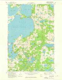
1973 Map of Lake Lida
USGS Topo · Published 1975About this map
Maplewood State Park dominates the southern half of this landscape, its boundaries encompassing a dense concentration of glacial lakes and recreational infrastructure. During the early 1970s, this area of Otter Tail County was characterized by its intricate water network, including the expansive Lake Lida and Star Lake. The terrain is marked by significant elevation changes around the shoreline of the South Arm, where campgrounds and the Park Headquarters supported the region's burgeoning seasonal tourism. Away from the larger lakes, small rural landmarks like Maplewood Ch and several cemeteries provide touchpoints for local genealogy. The map also documents the transition from undeveloped wetlands to established recreational sites, noted by numerous boat ramps and the identification of Stoney Bar, reflecting the area's importance as a central Minnesota destination for water-based activities and conservation.
Find a feature on this map
39 named features on this map. Tap any name to fly to it.
Don’t see what you’re looking for? This feature index may not catch every label — zoom into the map to look around manually.
Map Details
Editions of this 1973 Lake Lida Map
This is the sole edition of this map. No revisions or reprints were ever made.
Other maps of this area

1912 · Vergas
USGS Topo · 1:62,500

1913 · Fergus Falls
USGS Topo · 1:62,500

1914 · Pelican Rapids
USGS Topo · 1:62,500

1915 · Underwood
USGS Topo · 1:62,500

1915 · Vergas
USGS Topo · 1:62,500

1917 · Pelican Rapids
USGS Topo · 1:62,500

1953 · Fargo
USGS Topo · 1:250,000

1953 · Brainerd
USGS Topo · 1:250,000

1956 · Fargo
USGS Topo · 1:250,000

1957 · Brainerd
USGS Topo · 1:250,000