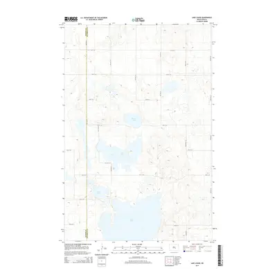
2014 Map of Lake Louise
USGS Topo · Published 2014About this map
Chase Lake dominates the southern portion of this landscape on the border of Kidder and Stutsman counties. This prairie pothole region is defined by a dense network of terminal lakes and smaller wetlands, including Chicago Lake, Fisher Lake, and the namesake Lake Louise. The survey reflects a sparsely populated agricultural environment where movement is dictated by a strict grid of section-line roads, such as 53rd Ave SE and 28th St SE. The topography reveals a complex glacial terrain of kames and kettles, where the absence of established towns highlights the reliance on large-scale land management. This map serves as a detailed record of the hydrological state of these seasonal and permanent water bodies as they appeared during the early 21st century.
Find a feature on this map
21 named features on this map. Tap any name to fly to it.
Don’t see what you’re looking for? This feature index may not catch every label — zoom into the map to look around manually.
Map Details
Editions of this 2014 Lake Louise Map
This is the sole edition of this map. No revisions or reprints were ever made.
Other maps of this area

1952 · Tappen NE
USGS Topo · 1:24,000

1952 · New Rockford
USGS Topo · 1:250,000

1953 · Jamestown
USGS Topo · 1:250,000

1954 · Medina
USGS Topo · 1:24,000

1955 · Crystal Springs
USGS Topo · 1:24,000

1956 · New Rockford
USGS Topo · 1:250,000

1956 · Jamestown
USGS Topo · 1:250,000

1971 · New Rockford
USGS Topo · 1:250,000

1972 · Woodworth
USGS Topo · 1:24,000
1972 · Lake Louise
USGS Topo · 1:24,000