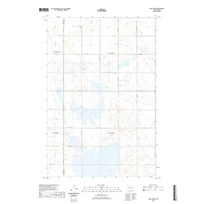
2020 Map of Lake Louise
USGS Topo · Published 2020About this map
Chase Lake dominates the southern landscape of this prairie wetland region, where the county line between Kidder Co and Stutsman Co runs through a series of significant water bodies. The terrain is defined by its hydrography, featuring a cluster of large basins including Lake Louise, Chicago Lake, and Fisher Lake. These permanent water features are connected by a regular grid of section roads, such as 48th Ave SE and 25th St SE, which provide access to the surrounding agricultural tracts. This 2020 survey illustrates a characteristic North Dakota landscape where the natural depressions of the Drift Prairie have created a vital wetland network amidst the Public Land Survey System's rigid township and range boundaries, specifically within t141n r69w and its neighboring sections.
Find a feature on this map
23 named features on this map. Tap any name to fly to it.
Don’t see what you’re looking for? This feature index may not catch every label — zoom into the map to look around manually.
Map Details
Editions of this 2020 Lake Louise Map
This is the sole edition of this map. No revisions or reprints were ever made.
Other maps of this area

1952 · Tappen NE
USGS Topo · 1:24,000

1952 · New Rockford
USGS Topo · 1:250,000

1953 · Jamestown
USGS Topo · 1:250,000

1954 · Medina
USGS Topo · 1:24,000

1955 · Crystal Springs
USGS Topo · 1:24,000

1956 · New Rockford
USGS Topo · 1:250,000

1956 · Jamestown
USGS Topo · 1:250,000

1971 · New Rockford
USGS Topo · 1:250,000

1972 · Woodworth
USGS Topo · 1:24,000
1972 · Lake Louise
USGS Topo · 1:24,000