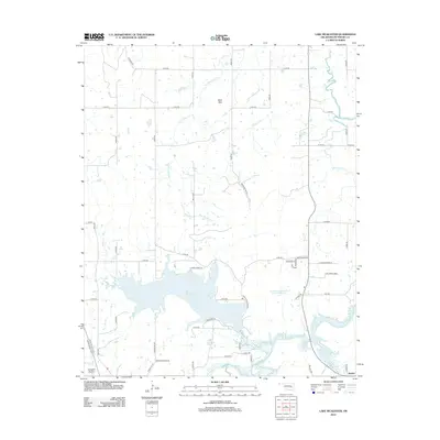
2012 Map of Lake McAlester
USGS Topo · Published 2012About this map
Lake McAlester dominates the southern half of this landscape, its irregular shoreline defined by the surrounding drainage of Bald Mountain Cr and Medicine Cr. The terrain north of the lake is characterized by a structured grid of county roads, such as Rainbow Rd and N4050 Rd, which cut through the watershed beneath Bald Mtn. In the southeast, the settlement of Mekko is situated near the confluence of Coal Cr and Wildhorse Cr, while Coal Creek Addn and residential developments along Lakeshore Dr show the area's modern footprint.
Find a feature on this map
54 named features on this map. Tap any name to fly to it.
Don’t see what you’re looking for? This feature index may not catch every label — zoom into the map to look around manually.
Map Details
Editions of this 2012 Lake McAlester Map
This is the sole edition of this map. No revisions or reprints were ever made.
Other maps of this area

1898 · McAlester
USGS Topo · 1:125,000

1900 · Canadian
USGS Topo · 1:125,000

1909 · Mc Alester
USGS Topo · 1:125,000

1946 · Fort Smith
USGS Topo · 1:250,000

1950 · Mcalester
USGS Topo · 1:250,000

1962 · McAlester
USGS Topo · 1:250,000

1965 · Fort Smith
USGS Topo · 1:250,000

1965 · McAlester
USGS Topo · 1:250,000
1966 · Haywood
USGS Topo · 1:24,000

1967 · Fort Smith
USGS Topo · 1:250,000