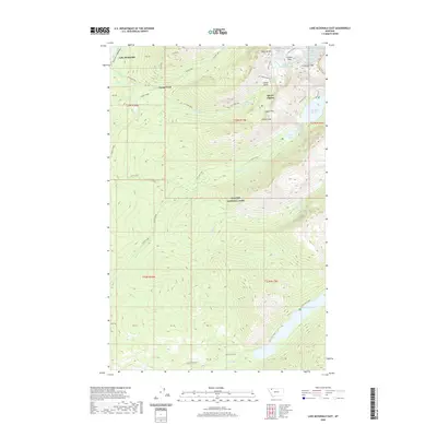
2020 Map of Lake McDonald East
USGS Topo · Published 2020About this map
Sperry Chalets serves as a focal point for this high-altitude landscape within Glacier National Park. The terrain is defined by dramatic elevation changes, featuring the Sperry Glacier and numerous alpine basins like Glacier Basin. Water flows through a complex network of creeks such as Spreague Cr and Snyder Cr, punctuated by significant vertical drops at Akaigan Falls and Feather Woman Falls. The presence of several remote lakes, including Lake Ellen Wilson and Harrison Lake, suggests a landscape shaped by glacial activity. At lower elevations, the shore of Lake McDonald and the Avalanche Campground indicate the primary access points for travelers entering this wilderness area. High mountain passes like Gunsight Pass and Lincoln Pass provide the only navigable routes through the high ridges of Snyder Ridge and peaks such as Edwards Mtn.
Find a feature on this map
48 named features on this map. Tap any name to fly to it.
Don’t see what you’re looking for? This feature index may not catch every label — zoom into the map to look around manually.
Map Details
Editions of this 2020 Lake McDonald East Map
This is the sole edition of this map. No revisions or reprints were ever made.
Other maps of this area

1904 · Chief Mountain
USGS Topo · 1:125,000

1914 · Nyack
USGS Topo · 1:125,000

1938 · Chief Mountain
USGS Topo · 1:125,000

1960 · Cut Bank
USGS Topo · 1:250,000

1963 · Cut Bank
USGS Topo · 1:250,000

1964 · Cut Bank
USGS Topo · 1:250,000

1964 · Nyack
USGS Topo · 1:24,000

1964 · Stanton Lake
USGS Topo · 1:24,000
1964 · West Glacier
USGS Topo · 1:24,000
1968 · Lake Mc Donald West
USGS Topo · 1:24,000