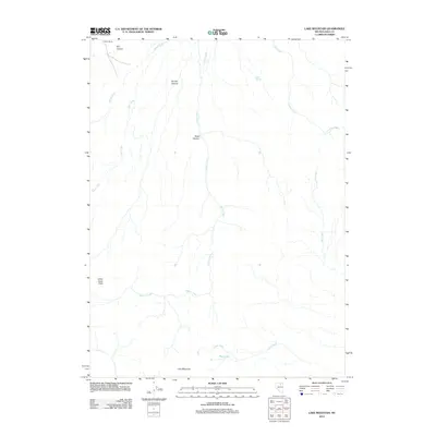
2012 Map of Lake Mountain
USGS Topo · Published 2012About this map
Packer Ranch and Indian Creek Field anchor this high-desert landscape in northeastern Nevada, showing the persistent presence of ranching and remote land use in Elko County during the early 21st century. The terrain is defined by a complex network of ephemeral drainages and canyons, including Bronco Canyon, Dry Canyon, and Road Canyon, all of which contribute to the larger watershed of Indian Creek. Towards the southern edge of the quadrangle, the prominence of Lake Mountain overlooks the seasonal water features of The Lakes and the headwaters of Lake Creek. This survey captures the arid character of the Great Basin, where named water sources like Suttle Spring and the meandering Crooked Creek were essential landmarks for navigation and land management.
Find a feature on this map
14 named features on this map. Tap any name to fly to it.
Don’t see what you’re looking for? This feature index may not catch every label — zoom into the map to look around manually.
Map Details
Editions of this 2012 Lake Mountain Map
This is the sole edition of this map. No revisions or reprints were ever made.
Other maps of this area

1955 · McDermitt
USGS Topo · 1:250,000

1956 · Tuscarora
USGS Topo · 1:62,500

1956 · Mt. Blitzen
USGS Topo · 1:62,500

1958 · Blue Basin
USGS Topo · 1:24,000

1959 · McDermitt
USGS Topo · 1:250,000

1970 · Sugarloaf Butte
USGS Topo · 1:24,000

1970 · Lake Mountain
USGS Topo · 1:24,000

1970 · Stampede Ranch
USGS Topo · 1:24,000
1970 · Beaver Peak
USGS Topo · 1:24,000
1970 · Beaver Creek
USGS Topo · 1:24,000