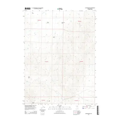
2014 Map of Lake Mountain
USGS Topo · Published 2014About this map
Independence Valley and the surrounding high-desert terrain of northern Nevada are the focus of this 2014 survey. The landscape is defined by its complex drainage network, where Indian Cr and Ham Cr flow through several named geographic corridors including Bronco Canyon and Dry Canyon. The topography rises toward Lake Mtn in the southern portion of the quadrangle, overlooking The Lakes and Williams Canyon. A singular point of water in this arid environment, Suttle Spring, is located near the northern edge of the valley. The absence of modern development on this map emphasizes the preservation of traditional land use areas like Indian Creek Field, offering a clear view of the natural basin and range structure that has shaped Elko County's ranching and wilderness history for generations.
Find a feature on this map
21 named features on this map. Tap any name to fly to it.
Don’t see what you’re looking for? This feature index may not catch every label — zoom into the map to look around manually.
Map Details
Editions of this 2014 Lake Mountain Map
This is the sole edition of this map. No revisions or reprints were ever made.
Other maps of this area

1955 · McDermitt
USGS Topo · 1:250,000

1956 · Tuscarora
USGS Topo · 1:62,500

1956 · Mt. Blitzen
USGS Topo · 1:62,500

1958 · Blue Basin
USGS Topo · 1:24,000

1959 · McDermitt
USGS Topo · 1:250,000

1970 · Sugarloaf Butte
USGS Topo · 1:24,000

1970 · Lake Mountain
USGS Topo · 1:24,000

1970 · Stampede Ranch
USGS Topo · 1:24,000
1970 · Beaver Peak
USGS Topo · 1:24,000
1970 · Beaver Creek
USGS Topo · 1:24,000