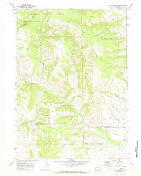
1969 Map of Lake Mountain
USGS Topo · Published 1973About this map
Bridger National Forest dominates the northern expanse of this 1969 survey, where the high-altitude terrain of Deadline Ridge and Lake Mountain defines the local topography. This portion of Wyoming exhibits a landscape heavily shaped by industrial and agricultural water management, evidenced by the presence of a Gas Well near Beaver Dam and the Anderson Howard Canal in the southeast. The map captures the meeting point of the Sublette and Lincoln County line, crossing through the winding path of La Barge Creek. Small-scale resource extraction is noted through several Prospects located near Rock Creek, while the settlement at Viola serves as a lone named waypoint. Water sources like Miller Creek and Chapel Creek drain the western slopes, illustrating the complex drainage patterns vital to this high-country environment.
Find a feature on this map
23 named features on this map. Tap any name to fly to it.
Don’t see what you’re looking for? This feature index may not catch every label — zoom into the map to look around manually.
Map Details
Editions of this 1969 Lake Mountain Map
2 editions found
Other maps of this area

1936 · Cokeville
USGS Topo · 1:96,000

1942 · Cokeville
USGS Topo · 1:125,000

1945 · Fort Hill
USGS Topo · 1:62,500

1947 · Fort Hill
USGS Topo · 1:62,500

1955 · Preston
USGS Topo · 1:250,000

1958 · Preston
USGS Topo · 1:250,000

1962 · Preston
USGS Topo · 1:250,000
1967 · Coal Creek
USGS Topo · 1:24,000

1967 · Mount Thompson
USGS Topo · 1:24,000
1967 · Fontenelle Basin
USGS Topo · 1:24,000