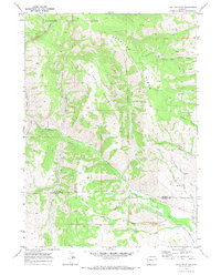
1969 Map of Lake Mountain
USGS Topo · Published 1973About this map
Deadline Ridge and Lake Mountain dominate this western Wyoming landscape, marking a rugged terrain within the Bridger National Forest. The survey captures the industrial and agricultural activity of the late 1960s, showing numerous Gas Wells and Drill Holes scattered across the high ridges, particularly near Beaver Dam Creek. In the lower elevations, the small settlement of Viola sits near the Anderson Howard Canal, reflecting the vital water management systems necessary for this arid region.
Find a feature on this map
23 named features on this map. Tap any name to fly to it.
Don’t see what you’re looking for? This feature index may not catch every label — zoom into the map to look around manually.
Map Details
Editions of this 1969 Lake Mountain Map
2 editions found
Other maps of this area

1936 · Cokeville
USGS Topo · 1:96,000

1942 · Cokeville
USGS Topo · 1:125,000

1945 · Fort Hill
USGS Topo · 1:62,500

1947 · Fort Hill
USGS Topo · 1:62,500

1955 · Preston
USGS Topo · 1:250,000

1958 · Preston
USGS Topo · 1:250,000

1962 · Preston
USGS Topo · 1:250,000
1967 · Coal Creek
USGS Topo · 1:24,000

1967 · Mount Thompson
USGS Topo · 1:24,000
1967 · Fontenelle Basin
USGS Topo · 1:24,000