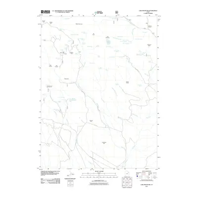
2011 Map of Lake Mountain
USGS Topo · Published 2011About this map
Little Water Mines sit at the center of this high-elevation landscape, where the extraction of natural resources meets protected wildlife habitats. The terrain is defined by a complex network of springs, such as Uranium Spring, Prospector Spring, and Warden Spring, which indicate a long history of water management for mining and livestock in this arid portion of Uintah County. To the west, the Mosby Mountain Game Enclosure marks a significant area dedicated to wildlife management near Mosby Park.
Find a feature on this map
73 named features on this map. Tap any name to fly to it.
Don’t see what you’re looking for? This feature index may not catch every label — zoom into the map to look around manually.
Map Details
Editions of this 2011 Lake Mountain Map
This is the sole edition of this map. No revisions or reprints were ever made.
Other maps of this area

1885 · Ashley
USGS Topo · 1:250,000

1906 · Marsh Peak
USGS Topo · 1:125,000

1908 · Marsh Peak
USGS Topo · 1:125,000

1917 · Vernal
USGS Topo · 1:125,000

1954 · Vernal
USGS Topo · 1:250,000

1958 · Vernal
USGS Topo · 1:250,000

1960 · Vernal
USGS Topo · 1:250,000

1964 · Lapoint
USGS Topo · 1:24,000
1964 · Whiterocks
USGS Topo · 1:24,000
1964 · Vernal NW
USGS Topo · 1:24,000