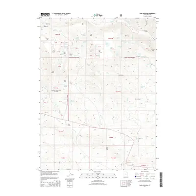
2014 Map of Lake Mountain
USGS Topo · Published 2014About this map
Ashley National Forest dominates this Uintah County landscape, where the high-altitude terrain is defined by a complex network of springs and drainage systems. The presence of Uranium Spring and Prospector Spring points to a history of mineral exploration in the mid-20th century, contrasting with the recreational and agricultural utility of landmarks like Bills Park and the settlement at Little Valleys. Water management is central to the area's character, evidenced by the numerous named sources such as Gull Lake, Walkup Spring, and the Dry Fork which carves through the northern reaches. The topography rises sharply toward Lake Mountain and the jagged Sawtooth Ridge, while the Chalk Cliffs and Little Water Hills provide distinct geological markers for those navigating the backcountry. High-elevation access is facilitated by the Red Cloud Loop, connecting these remote alpine features.
Find a feature on this map
96 named features on this map. Tap any name to fly to it.
Don’t see what you’re looking for? This feature index may not catch every label — zoom into the map to look around manually.
Map Details
Editions of this 2014 Lake Mountain Map
This is the sole edition of this map. No revisions or reprints were ever made.
Other maps of this area

1885 · Ashley
USGS Topo · 1:250,000

1906 · Marsh Peak
USGS Topo · 1:125,000

1908 · Marsh Peak
USGS Topo · 1:125,000

1917 · Vernal
USGS Topo · 1:125,000

1954 · Vernal
USGS Topo · 1:250,000

1958 · Vernal
USGS Topo · 1:250,000

1960 · Vernal
USGS Topo · 1:250,000

1964 · Lapoint
USGS Topo · 1:24,000
1964 · Whiterocks
USGS Topo · 1:24,000
1964 · Vernal NW
USGS Topo · 1:24,000