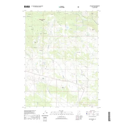
2020 Map of Lake Mountain
USGS Topo · Published 2020About this map
Ashley National Forest dominates this high-elevation landscape in Uintah County, where complex hydrology and sharp relief define the terrain. The presence of features like the Dry Fork Flume and a dense network of water sources, including Mule Hollow Spring and Warden Spring, suggests a region managed for seasonal resource use and water distribution. To the east, the Deep Creek Ranch marks one of the few named settlements in a region otherwise characterized by geological landmarks such as the Chalk Cliffs and Sawtooth Ridge. Navigation through this backcountry is facilitated by primitive routes like Treaty Rd and Paradise Park Rd, which wind between significant peaks such as Mosby Mtn and Lake Mountain. The naming conventions here, from Weasel Point to Alcorn Hollow, reflect a history of local exploration and the essential reliance on the many seeps and springs scattered throughout the Little Water Hills.
Find a feature on this map
80 named features on this map. Tap any name to fly to it.
Don’t see what you’re looking for? This feature index may not catch every label — zoom into the map to look around manually.
Map Details
Editions of this 2020 Lake Mountain Map
This is the sole edition of this map. No revisions or reprints were ever made.
Other maps of this area

1885 · Ashley
USGS Topo · 1:250,000

1906 · Marsh Peak
USGS Topo · 1:125,000

1908 · Marsh Peak
USGS Topo · 1:125,000

1917 · Vernal
USGS Topo · 1:125,000

1954 · Vernal
USGS Topo · 1:250,000

1958 · Vernal
USGS Topo · 1:250,000

1960 · Vernal
USGS Topo · 1:250,000

1964 · Lapoint
USGS Topo · 1:24,000
1964 · Whiterocks
USGS Topo · 1:24,000
1964 · Vernal NW
USGS Topo · 1:24,000