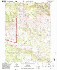
1996 Map of Lake Mountain
USGS Topo · Published 1999About this map
Ashley National Forest dominates the high-elevation landscape of this Uintah County survey, where the northern border of the Uintah and Ouray Indian Reservation meets the steep slopes of Mosby Mountain. The terrain is characterized by complex hydrology, evidenced by the numerous named water sources such as Lightning Spring, Uranium Spring, and Prospector Spring. These labels, along with the Little Water Mines and various Gravel Pits in the south, point to a history of resource extraction and prospecting in the high desert.
Find a feature on this map
61 named features on this map. Tap any name to fly to it.
Don’t see what you’re looking for? This feature index may not catch every label — zoom into the map to look around manually.
Map Details
Editions of this 1996 Lake Mountain Map
This is the sole edition of this map. No revisions or reprints were ever made.
Other maps of this area

1885 · Ashley
USGS Topo · 1:250,000

1906 · Marsh Peak
USGS Topo · 1:125,000

1908 · Marsh Peak
USGS Topo · 1:125,000

1917 · Vernal
USGS Topo · 1:125,000

1954 · Vernal
USGS Topo · 1:250,000

1958 · Vernal
USGS Topo · 1:250,000

1960 · Vernal
USGS Topo · 1:250,000

1964 · Lapoint
USGS Topo · 1:24,000
1964 · Whiterocks
USGS Topo · 1:24,000
1964 · Vernal NW
USGS Topo · 1:24,000