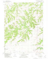
1981 Map of Lake Mt. Sterling
USGS Topo · Published 1981About this map
The rugged drainage systems of Missouri Creek and its tributaries carve through the central landscape, defining the character of the Pea Ridge area during the early 1980s. A dense network of family-named cemeteries, including the Clark-Campbell Cem and Reynolds Cem 2, suggests the deep genealogical roots of the rural settlements in this part of Brown and Schuyler Counties.
Find a feature on this map
33 named features on this map. Tap any name to fly to it.
Don’t see what you’re looking for? This feature index may not catch every label — zoom into the map to look around manually.
Map Details
Editions of this 1981 Lake Mt. Sterling Map
This is the sole edition of this map. No revisions or reprints were ever made.
Other maps of this area

1923 · Rushville
USGS Topo · 1:62,500

1926 · Rushville
USGS Topo · 1:62,500

1926 · Mt Sterling
USGS Topo · 1:62,500

1928 · Meredosia
USGS Topo · 1:62,500

1929 · Mt Sterling
USGS Topo · 1:62,500

1931 · Meredosia
USGS Topo · 1:62,500

1946 · Augusta
USGS Topo · 1:62,500

1948 · Quincy
USGS Topo · 1:250,000

1949 · Augusta
USGS Topo · 1:62,500

1956 · Quincy
USGS Topo · 1:250,000