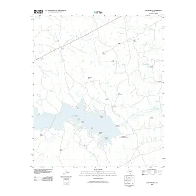
2010 Map of Lake Murvaul
USGS Topo · Published 2010About this map
Lake Murvaul dominates the southern half of this landscape, its complex shoreline defined by numerous points and inlets such as Moss Point, Long Point, and Dudley Williams Point. The surrounding Panola County terrain is a network of small creeks and branches, including West Fork Indian Creek, Sessums Creek, and Colo Creek, which feed into the primary reservoir. Established settlements like Clayton, Snap, and Buncome anchor the rural road network, reflecting the longstanding agricultural and residential character of the region.
Find a feature on this map
48 named features on this map. Tap any name to fly to it.
Don’t see what you’re looking for? This feature index may not catch every label — zoom into the map to look around manually.
Map Details
Editions of this 2010 Lake Murvaul Map
This is the sole edition of this map. No revisions or reprints were ever made.
Other maps of this area

1953 · Palestine
USGS Topo · 1:250,000

1956 · Tyler
USGS Topo · 1:250,000

1957 · Palestine
USGS Topo · 1:250,000

1958 · Timpson
USGS Topo · 1:62,500

1958 · Carthage
USGS Topo · 1:62,500

1960 · Minden
USGS Topo · 1:62,500

1960 · Mount Enterprise
USGS Topo · 1:62,500

1983 · Long Branch
USGS Topo · 1:24,000

1983 · Fair Play
USGS Topo · 1:24,000
1983 · Gary
USGS Topo · 1:24,000